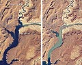
A prolonged drought that has caused Lake Powell on the Colorado River to shrink significantly over the last decade has eased slightly, according to recent data. But, as documented in a series of satellite images released by NASA, the water levels are still far from the 1999 levels when the lake was near full capacity. Water levels in Lake Powell, a meandering reservoir created by the Glen Canyon Dam and straddling the Utah and Arizona border, dropped significantly in the years following 1999 as a result of drought and water removal for human use. Dry conditions reached their nadir in early 2005, during which the northwestern branch of the reservoir was cut off from the rest of Lake Powell and large parts of the dry canyon floor became visible. By this spring the effects of the drought had eased somewhat. The peak inflow to the lake is mid- to late- spring when Rocky Mountain snowpack melts. According to the Bureau of Reclamation, the flow of water into Lake Powell in April was higher than forecast, although that may be due to an earlier-than-expected spring thaw.
The Shrinking of Lake Powell
More From E360
-
Cities
In Steel Country, the Fight for Clean Air Faces New Obstacles
-
Solutions
Beyond Lithium: New Battery Tech Starts to Break Through
-
INTERVIEW
What Do We Actually Know About the Microplastics Inside Us?
-
Energy
A Home Battery Revolution Is Reshaping the Power Grid
-
Energy
In East Africa, a Controversial Oil Project Is Poised for Production
-
Climate
A Missing Piece in Climate Models: Nature’s Own Emissions
-
INTERVIEW
An EPA Researcher Details the Agency’s Assault on Science
-
Oceans
Efforts to Save Kelp Forests from Ocean Warming Are Ramping Up
-
Biodiversity
Pollution Is Changing the Smells of Nature, With Risks for Wildlife
-
Oceans
Supertrawlers Are Taking Antarctic Krill That Whales Depend On
-
INTERVIEW
The U.S. Senator Who Won’t Shut Up about Climate Change
-
Energy
A First Among Major Nations, India Is Industrializing With Solar