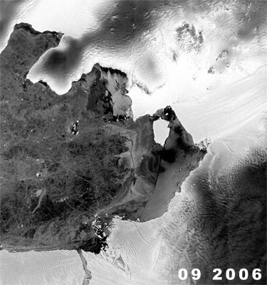
Roughly 190 miles long and 30 miles wide, the Pine Island Glacier — known to scientists who study it as the PIG — is one of Antarctica’s largest ice streams. As NASA scientist Robert Bindschadler notes, it is also the continent’s fastest-moving glacier, discharging more ice into the sea than any other glacier in Antarctica.
Flowing out of the heart of West Antarctica, the Pine Island Glacier rests partly on land and partly in a submarine basin, where it is grounded more than a thousand feet beneath the ocean’s surface on bedrock. Now, shifting
Antarctic ocean currents — attributable, many scientists contend, to rising global temperatures and increasing winds — are forcing warmer water up onto Antarctica’s continental shelf and eating away at the underside of the Pine Island Glacier. As a result, Bindschadler explained in an interview with Yale Environment 360, parts of the floating ice shelf at the end of the glacier are thinning 160 feet a year and, with its hold on bedrock weakening, the PIG is now roaring into the sea at a rate of a foot an hour — more than two miles annually. The volume of ice that the Pine Island Glacier is losing every year is staggering: 46 billion tons, a significant contribution to rising global sea level.
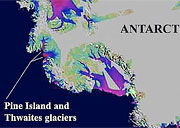
Bindschadler — chief scientist of NASA’s Hydrospheric and Biospheric Sciences Laboratory, a senior fellow at the Goddard Space Flight Center, and leader of 15 Antarctic field expeditions — is one of the key players in a multi-year, international research project that is attempting to determine exactly what is causing the Pine Island Glacier and a neighbor, the Thwaites Glacier, to thin and accelerate so rapidly. The logistical challenges of this work are enormous, as Pine Island is 1,400 miles from the nearest U.S. base at McMurdo.
In this interview with Yale Environment 360 senior editor Fen Montaigne, Bindschadler talked about the urgency of his mission. Given his unique vantage point, his forecasts for global sea level rise this century are sobering: Ocean levels will almost certainly rise by 3 feet, says the NASA scientist, and a 6-foot increase is not out of the question.
Yale Environment 360: How does the size of the Pine Island Glacier and ice shelf compare with the Ross Ice Shelf or other great ice shelves of Antarctica?
Robert Bindschadler: It’s tiny by comparison with the Ross Ice Shelf, which is the biggest, or the Ronne Ice Shelf, which is the next biggest. But Pine Island Glacier and the Thwaites Glacier add up to quite a sizeable portion of ice, all the same. Certainly a lot more is going on at Pine Island: melt rates are ten to fifty times more than underneath those big Ross and Ronne Ice Shelves.
e360: Why do you think the melt rates are so much greater underneath Pine Island?
Bindschadler: One reason is it’s deeper underwater. Another reason is that the warm water has an easier time getting to the glacier from the middle layer of the Southern Ocean, which is where the heat is. So the continental shelf is just at the right depth to allow that warmer water a small upward nudge to get up onto the shelf and it gets directed right towards the glacier. We’re pretty sure that this is why this part of West Antarctica is acting in such a dramatic way. The glacier is thinning rapidly and accelerating five to ten percent per year. It’s just a huge rate of change.
e360: Can you explain the significance of that acceleration factor that you’re talking about?
Bindschadler: There are two places in Antarctica that are really changing rapidly. One is the Antarctic Peninsula, where ice shelves are disintegrating, and the glaciers that feed them are accelerating into that open [ocean] embayment. And the other place is along the north coast of West Antarctica, and primarily these glaciers, Pine Island Glacier and Thwaites Glacier. And we see the largest rates of thinning right at the coast, and then it decays in magnitude as you go inland. And that’s a pretty obvious signature that change is being triggered right at the coast, and it’s just propagating inland.
This ice shelf, which five years ago was moving about 2½ kilometers a year, is now going about 3½ kilometers a year, and that converts to a foot an hour. It’s just racing along, an astonishing rate of change. And the reason we’re concerned is that this leads to more ice being discharged from the continent, and that ice, as it goes into the ocean, raises sea level around the world. And because so many people live at the coast, that draws our attention to Antarctica, and how fast the ice sheet is shrinking. We know that in the big picture, Earth is getting warmer and there’s going to be less ice. But we don’t know the details — how fast, how much sea level is going to go up — and that detail is really important because humans around the planet are so sensitive to even a tiny change in sea level.
“The ice shelf is just racing along, an astonishing rate of change.”
e360: Are you saying that the rate of acceleration of the Pine Island and Thwaites glaciers is so rapid because of changes at their seaward ends, and so much more ice is coming off the continent into the water that this obviously is going to impact sea level rise?
Bindschadler: That’s an important point and an issue that was hotly debated in the glaciological community for the last twenty years — this idea of, do the ice shelves matter to the ice upstream that is grounded, in regards to sea level rise? But in the Antarctic Peninsula, we finally got a definitive answer, because there the perfect natural experiment was run for us and we got to observe it, where these ice shelves like the Larsen B rapidly disintegrated over the course of just a few weeks. It was there, then it’s not there, and we were able to see that the glaciers that fed that ice shelf accelerated dramatically, more than 500 percent in just a couple years. So, that really settled the debate, told us that, yes, the ice shelves do buttress the ice upstream, and if you get rid of the ice shelf, the ice upstream really accelerates and it comes running into the ocean, and it will change sea level. In the case of Pine Island and Thwaites, the ice shelf hasn’t disintegrated, but it’s thinning quite rapidly, so it’s gradually going away and allowing the ice upstream to accelerate more and more.
e360: And in the theoretical case that Pine Island and Thwaites glaciers completely dump into the ocean — obviously it’s not going to happen in the near-future — what kind of sea level rise would they contribute to?
Bindschadler: That portion of West Antarctica, that third that flows northward primarily through those two glaciers, has the potential to raise sea level 1 ½ meters. That’s sort of an upper bound, a worst case. But the time scale is what really matters. Some say that we won’t see these ice shelves disappear in our lifetime — I’m not so sure. I think we might well.
e360: Are you kidding?
Bindschadler: No, no at all.
e360: When you think how cold Antarctica is, with a polar plateau that’s two to three miles thick, all ice, one would think it’s going to be thousands of years before the main part of the continent would start to feel the effects of warming. But you’re saying, not at all.
Bindschadler: Maybe not. There is still some debate about that. If there’s one place on the planet that is still sort of isolated from that global signal, it is Antarctica. The circulation of the ocean and the atmosphere around the Southern Ocean tends to isolate the main body of Antarctica, while at the same time, the peninsula is sensitively exposed to it. The jury is still out as to how rapidly that warming is going to penetrate the main continent, but the most recent results say that West Antarctica has been warming, too. The underside of the ice sheet and the ice shelves are vulnerable spots, and that’s what our project is addressing. And that just goes back to what I said earlier — there’s also heat in the intermediate layers of the Southern Ocean, and certainly at Pine Island and Thwaites. We’re firmly of the opinion that heat is getting to the ice and causing these major changes. So even if you isolate Antarctica somewhat on the surface from global warming, there’s this back door where heat is still getting to this part of the ice sheet.
“Some say that we won’t see these ice shelves disappear in our lifetime — I’m not so sure.”
e360: So what you’re saying is that with Pine Island and Thwaites, these changes are primarily due not to air temperatures, but to small increases in sea temperature?
Bindschadler: That’s right. And it’s not so much that the water is getting warmer, it’s just where the warm water resides is being lifted up. And we think that’s due to increased winds … You’re kind of pushing the surface water out of the way, so deeper water has to come up to replace it. So you get an increased upwelling of that warmer water. And so now you’ve delivered that extra heat, and you’ve set the stage, then, for the increased melting and thinning of the ice shelves, and the acceleration of the ice sub-stream into the ocean.
e360: Can you describe how the Pine Island Glacier spreads from land to sea?
Bindschadler: It has branches and tributaries that feed into it. So it looks the trunk of a tree with some big branches. And that’s the glacier. As it flows out of the center of the ice sheet towards the edge, the trunk of the glacier grows, the ice gets thinner and thinner, with the bed below sea level, and the flow rate increases. At some point, called the grounding line, you reach a thickness where it’s thin enough that it will come afloat. And at that point the grounded nature of the ice sheet stops and a floating ice shelf starts to form. Then you’re on the Pine Island Ice Shelf. It’s about 35 kilometers wide and 40 kilometers long.
e360: What is the mechanism by which you get the thinning? Is it simply a melting of that undersea ice? Does it loosen the ice’s grip on the bedrock of the ocean?
Bindschadler: We think it’s primarily melting at very high rates. We’re talking about fifty meters per year of ice being melted right at that grounding line, right where the glacier finally gets thin enough to come afloat, and the water has first access and deepest access to the glacier. And part of it is because the water is warm: maybe 2° or 3° C. Both in Greenland and in Antarctica, it’s where these really thick, deep glaciers are coming off the continent and coming into contact with water, that we see the most dramatic change.
e360: Tell me a little bit about the work you’ve been doing and plan to do on Pine Island and some of the new technologies that you plan to employ there.
Bindschadler: We’re right at the edge in a lot of ways. This is urgently needed science. We can’t predict what the ice sheet is going to do until we understand why the ice sheet is doing something so dramatic here. So that’s the edge of science. We’re right at the edge of the logistic capability too — a long way from anywhere and needing helicopters to get way out there. Technologically it’s tough because nobody has studied this kind of environment before.
So what we’re going to do is go in with a hot water drilling system. You melt snow, you make it hot with commercial car wash heaters, you pump it through a high-pressure hose, and you melt your way through the ice. The ice where we want to penetrate is about 600 or 700 hundred meters thick,
and so you make a hole. That’s pretty easy to do. Then we’re going to put in a new video camera system to look at the underside of the ice shelf, and to look at the water right there.
Next we’re going to deploy a brand new oceanographic instrument profiler that one of the investigators on our team is putting together to measure the properties of the water: temperature, current, salinity, all the important parameters that tell oceanographers about the water. And it’s going to be deployed on a cable, so it can do vertical profiles; it can run up and down this cable by adjusting its buoyancy. It will transmit its data inductively into the cable, and be read by a sensing unit on the surface. Then it will phone the data back to this investigator’s computer in California by Iridium satellite phones.
Ultimately we’ll lose the oceanographic instrument profiler. The hole will freeze shut, sealing this profiler beneath the ice shelf. But it will continue to operate, we hope, for about three years, and give us a continuous record of what kind of water is coming in, what kind of water is going out, and allowing us to calculate how much heat is being converted to melted ice.
We’ve already left an automated weather station that has been sending data back to us. We will be using seismic exploration techniques to measure the depth of the water cavity under the shelf. We would be using radar to measure the thickness of the ice and the melting rate at a bunch of spots. We’ll put out some more GPS’s directly on the ice to measure the acceleration rate.
We’re pushing the frontiers of science and technology and the urgency to get these answers is that these latest satellite observations show us that our very best models of ice sheet flow simply do not work. They cannot reproduce these really large rates of melt and acceleration of the ice. So we have to understand the processes better so we can put them into the models, so the models can give us the best chance of predicting the future of the ice sheets.
e360: So basically at places like Pine Island, the models have been underestimating the rates of thinning and acceleration?
Bindschadler: Very much so, yeah. So when the IPCC report came out, it had numbers for sea level rise predictions through this century. But it also said, “We don’t know if these numbers are right, because they do not include the most recent dramatic changes in ice sheet behavior, because we can’t model that.” So what it really said, to me, is that, “Here’s some numbers, but don’t trust the numbers because they’re probably hideously low.” But it was a call to action to my community, the ice sheet dynamic community, to get moving and provide the very best numbers that we can.
“The latest satellite observations show us that our very best models of ice sheet flow do not work.”
e360: I know that the IPCC was saying maybe 1½ feet or a half-meter of sea level rise in the 21st century. Is it your opinion that we could be looking at significantly larger sea level rise?
Bindschadler: Yeah, I think there’s sort of an unspoken consensus in my community that if you want to look at the very largest number in the IPCC report, they said 58 centimeters, so almost two feet by the end of the century. That’s way low, and it’s going to be well over a meter. We may see a meter by the middle of the century.
e360: Oh my gosh.
Bindschadler: And if this behavior that we’re seeing in Pine Island, and even Greenland continues — and we don’t see any reason why it wouldn’t continue — well, over a meter by the end of the century, I think is almost certain.
e360: And some people are saying that two meters is certainly not out of the realm of possibility in the 21st century.
Bindschadler: Absolutely. That’s correct, yeah.
e360: Have you been taken aback by the rapidity of the changes in the ice sheets and glaciers both in West Antarctica and Greenland?
Bindschadler: Yeah, absolutely astounded.
e360: Is the urgency you’re feeling a desire to have the data and the science to show the policy makers and the public the speed and scale of these changes so that we’ll react?
Bindschadler: Yeah, I mean, pick your country. Almost every country has some sensitivity to sea level change. Obviously the Netherlands and the Gulf Coast of the U.S. and Bangladesh are incredibly sensitive, and China as well. And if you’re asked to invest billions of dollars in some kind of sea barrier, because we think sea level might go up a meter, or it might only go up half a meter, or it might go up a meter and a half, you know, you’re not going to be content with a wishy-washy answer. We want to be able to say that the likelihood is X percent that it’s going to go up Y meters by the end of the century, and you better prepare for it. So I think there’s no question that an increased credibility and precision in predicting — in my case, sea level — would have incredible advantages to countries and to individuals.