Even as populations of sharks, bluefin tuna, and other large fish are being severely over-exploited, scientists still know surprisingly little about when and where the ocean’s biggest predators congregate to feed and spawn, making it difficult to protect biological hot spots. Stanford University marine biologist Barbara Block is seeking to narrow that knowledge gap by deploying an armada of satellite tags on the backs of ocean creatures.

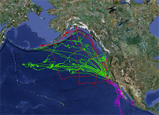
Block envisions a wired ocean, a blue fount of data in which tags, smart buoys, and mobile robots reveal the secrets of marine life. She and her colleagues have been involved in the Tagging of Pacific Predators project, a long-running study that has affixed more than 4,000 tags to 23 different species and revealed that the eastern Pacific is a veritable “blue Serengeti,” rich with life and traversed by regular migration routes.
In an interview with Yale Environment 360 contributor Ben Goldfarb, Block — the architect of Shark Net, an app for iPads and iPhones that allows subscribers to track great white sharks off the coast of California — discusses the wealth of data gathered by the latest electronic tags and explains why it’s important to put the fruits of this research into the public’s hands. “What we need is environmental interest and awareness that connects humans to the world,” says Block, “or else we’re going to end up with the same problem that we had on the continents, where the large mammals are gone.”
Yale Environment 360: I gather you’ve done a lot of the tag design yourself? How do you create a tag that then stays in these creatures for five years?
Barbara Block: Well, you first have to dream big. And you have to say, “What is it I want to know?” Back in the mid-90s, we were at the table at big fisheries commission meetings, where we really didn’t know where big fish went. And so we asked the question, “How could we study something underneath the sea, that breathes through the gill?” You can’t use radio waves because sound has to travel through air primarily to get anywhere… So we used a technique that was first talked about many years ago, in which we took light from the sun and measure photons, so we can actually put together sunrise and sunset data. We have an accurate clock on the tags. It’s what mariners have done for all of time — we’re using light and time to calculate our position from Greenwich.
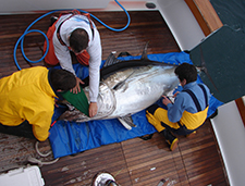
We try to use the same chips that are in your computer, the same devices that allow you to talk to satellites and cell phones, and we package them in small devices, put them on big animals like white sharks and tunas, and we follow them across the globe. What we’re trying to do is figure out how do big animals live in the ocean ecosystem, and where they are. And we’ve done this through huge tagging campaigns. One was in the Atlantic called “Tag a Giant” that focused on giant bluefin tuna, fish that are up to 1,500 pounds that carry these computer tags, sometimes up to four or five years. And we have a campaign in the Pacific we call “Tagging of Pacific Predators.” Over 5,000 animals have been tagged, 80 scientists working together, five nations, trying to figure out how the largest ocean on Earth works.
e360: I imagine that it’s incredibly hard to tag something like a blue whale or a white shark.
Block: For every animal it’s a different problem. For us, when we come face-to-face with a large shark, the goal is basically to get the tag on the animal with the least amount of challenges for the animal — great white sharks are sometimes as large as 5,000 to 7,000 pounds.
e360: How many of these tags do you have deployed at any given time?
Block: We have a data logger, or an archival tag. But with that archival tag, you have to get it back when humans intercept the fish. You can only put that into an animal that has a huge fishery, like a bluefin tuna. And we’ve put over 1,500 of those tags in tunas in the Atlantic and the Pacific Ocean. We get about 22 percent back in the Atlantic, 50 percent back in the Pacific, and when they come back, we download the information and find out where the animal’s been.
“It’s hard to imagine how we’re going to save animals and build conservation strategies when you can’t even see the animals.”
But we got tired of waiting for people to turn tags back in. So we worked with engineers and packaged [the tags] into a tube. It’s got a little float on the top, and it rides on the tuna, takes the data, rides on the shark, takes the data, pops off a small piece of steel that corrodes away, comes to the surface, and then sends the data back to Earth-orbiting satellites. And then we get data back without any human interception.
Then finally, there are tags you can put on the dorsal fin of sharks, and they use radio waves and talk to Earth-orbiting satellites every day. I looked up this morning the location of a salmon shark that came from Alaska to Monterey Bay in the last six months.
e360: One of the cool things that you’ve done is you’ve put a lot of this data in the hands of the public. Can you talk a little bit about your efforts to make this stuff publicly available?
Block: We want to engage the public because we’ve got some of Earth’s greatest critters out there, the big sharks and the tunas, and most people look at the ocean and can’t even see anything. So it’s hard to imagine how we’re going to save animals, or build conservation strategies, when you can’t even see the animals. So lately what we’re trying to do is transmit the data in ways that become browser-friendly on your internet site or iPhone. “Shark Net” is our app. It’s free, and it allows you to keep track of great white sharks on the west coast of North America, and hopefully soon we’ll bring some other sharks into that.
e360: You’ve also pioneered a lot of robotic technology, including something called a “wave glider.”
Block: The wave glider is built by Liquid Robotics. It’s a brand new technology, a green robot, and it’s a surfboard that is attached with a unique tether to a sub, or a glider. And it captures the motion of waves, and it is completely powered by the kinetic energy of waves. It then uses solar power to power the instruments on board. And right now we’re gliding off the coast of North Carolina and we’re seeing things like sand bar sharks, sturgeon, animals that are freely swimming in the sea that use acoustic tags that send sound waves to the underwater glider, which then is transmitted to us in real time through iridium uplinks from the glider.
e360: How many of these gliders do you have out there right now?
Block: Well, the company, Liquid Robotics, might have as many as 150 gliders that are plowing through the ocean looking for everything from natural gas, or oil, to helping us do our biological oceanography. We envision a day when our coastlines can be protected by devices that are telling us what ships are there, telling us in real time how the ocean is today. And then also finding out where these congregations of animals are — the hot spots — so that we might then put a marine protected area around them.
e360: Your Pacific Predator tagging study suggested that marine animals tend to use the same migratory corridors over and over. How do you go about protecting corridors once you’ve identified them?
Block: Well, we are still just identifying them, but we’re dreaming now of how to protect them. Think of a continent as large as Africa, and then imagine that we’re working in a geography that’s at least ten-fold larger. If you looked at Africa, you might say, where’s the Serengeti? Where’s the watering hole where you’d see zebras, gazelles, elephants? Well, we’re looking for that watering hole in the ocean.
e360: One of the hot spots that you identified is this so-called “white shark café.” What’s that?
Block: We’ve put over 200 tags on white sharks, including about a hundred satellite tags that ride on the animal and send us back the data. And what those satellite tags have taught us is when we tag a shark off the coast of Monterey Bay, it will travel thousands of miles — as far away as Hawaii — and halfway between Hawaii and California is an open region of the ocean that serves as a gathering spot of white sharks. And almost every white shark we tagged will go to this place. So our group dubbed it the White Shark Café.
We’ve never been there with our ships. We’ve never seen what’s happening there, but we can tell that white sharks gather there. We’re not sure if it’s for foraging or for sex, but that’s where the white sharks go. And one of the big projects for the future is we want to go out there with a variety of unmanned vehicles and tagged animals, and make this place clear to us in terms of what’s happening there.
e360: Do you ever worry that your tagging data will be used by fishing vessels to identify the hot spots and target the fish there?
Block: Yeah, we worry about it a lot. I think the Shark Café is a good example. So right now we’ve pointed out something that wasn’t really evident to a lot of international fishers, that there’s a region in the Pacific that’s relatively hot for large predators. We don’t know what the white sharks are doing there. They’re probably eating other animals, tunas or swordfish. There is lots of evidence that some types of tunas are gathered there. So that’s a good example of where we’ve put on a map the spot that few people knew about before us. So what we try to do is work with species that are protected when we put the data online, or the data in the public space. We can’t, for example, broadcast where giant bluefin tuna are on the day that we know where they are. [But] I’d say that most of the hot spots are well known hot spots, like the Grand Banks or Georges Bank.
e360: What have your white shark tagging studies revealed about the conservation status of white sharks? I understand that California’s currently considering listing them as an endangered species.
Block: We have a project to come up with a total number of sub-adult and mature white sharks in the vicinity of the central coast of California. The number we got is about 220 animals, which is very low.
There’s a second group of white sharks off the island of Guadalupe [off Baja California]. The number they’re getting down there is about 130 mature animals and sub-adults. And so you take those two numbers, and no matter how you cut it, that’s not a lot of white sharks.
“We need a system where, if you’re going to fish the public ocean space, we need to know what you’re catching.”
These white sharks have been found to be demographically isolated through the tagging and genetics that our team and others are doing. And so it does make sense that we’re at least considering, at a time when in many parts of the ocean white sharks are declining, what to do about the white sharks that are within this area of California. We have the beginnings of a census, and so what one might have to do is get that trend through time in order to understand, is the population expanding? Is it declining? We don’t know the answer yet.
e360: What might be the primary causes of white shark mortality? Are they being targeted by fishermen? Are they bycatch?
Block: Well, let’s come back to the area off the coast of Connecticut and Massachusetts, where I grew up, and we know that long-line and recreational fishers took from the Atlantic ocean on the western North Atlantic over 6,000 white sharks. Those numbers come from catch data. We don’t really know how many white sharks are there today, but we do know that when there are a few around Cape Cod, it creates quite a stir.
What we have to do is begin to understand what is the size of a healthy ecosystem’s white shark population. What happens when these populations have taken up in an ecosystem that is really altered? We’ve got less fish in certain places, in Georges Bank, and the Grand Banks. We have marine mammals protected and expanding their populations. So we’ve got this unusual situation where we hardly know what white sharks do. We do understand that as a large predator they love [to eat] marine mammals. As a youngster they’re eating fish. We don’t really know the status of the current population. We know it was big in the past. What’s the number you need to keep that ecosystem thriving?
e360: In other places, fishing gear has been modified to avoid bycatch of certain species. Has anything like that been tried with sharks?
Block: What we need to do now is ask where are sharks most vulnerable And the most vulnerable space is out in the open sea, in a gyre that spans from Hawaii to the California current. And in this region, there’s no protection. It’s the Wild West. That’s the place where longlines could catch a relatively small adult white shark. We also know that purse seines could intercept a white shark, too.
We need a system where, if you’re going to fish the public ocean space, we need to know what you’re catching. And that’s been the loophole that most international fisheries are falling through. It’s hard to put a human observer on every boat. It’s hard to know what they’re catching… And right now, nations are pretty much taking resources from the next generation out of our oceans today.
One idea is to put these hot spots on the map. If we can show everybody where [these species] are, we can then build open-ocean dynamic protected areas. If species are gathering because there’s some critter there that they’re all eating, then we can put this on the map, and naval ships and other vessels can move around these areas, and know not to conduct their maneuvers… We want to use existing structures like the [marine] sanctuaries. We want to expand their boundaries. We want to make them into more powerful entities. And to do that requires changing the rules. And so what we need is environmental interest and awareness that connects humans to the world, or else we’re going to end up with the same problem that we had on the continents, where the large mammals are gone.