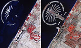
In these photographs, NASA satellites capture the explosive growth of Dubai on the Persian Gulf between 2002 and 2008. These false-color thermal images of Dubai — one of the 7 United Arab Emirates — depict vegetated areas in red, buildings in gray, and the desert in beige. The image at left, taken in October 2002, shows the early stages of construction of Palm Jumeirah, a vast commercial development built by dredging 3.9 billion cubic feet of sand from the gulf and depositing it in the shape of a giant palm tree. The finished look of Palm Jumeirah — which contains shops, hotels, and apartments and is protected from the gulf by 7 miles of rocky breakwater — can be seen in the image at right, taken in November 2008. That recent image also shows the exponential growth of Dubai, a city-state of 1.2 million and a major commercial hub in the oil-rich Persian Gulf region. Just to the east of Palm Jumeirah, the fairways of an irrigated golf course, pictured in red, can be seen.
Dubai’s Urban Sprawl
More From E360
-
Energy
Why U.S. Geothermal May Advance, Despite Political Headwinds
-
Food & Agriculture
In War Zones, a Race to Save Key Seeds Needed to Feed the World
-
Climate
Lightning Strikes the Arctic: What Will It Mean for the Far North?
-
RIVERS
A Win for Farmers and Tribes Brings New Hope to the Klamath
-
Solutions
Deconstructing Buildings: The Quest for New Life for Old Wood
-
NATURAL DEFENSES
How Restored Wetlands Can Protect Europe from Russian Invasion
-
Solutions
Birds vs. Wind Turbines: New Research Aims to Prevent Deaths
-
FORESTS
Cambodian Forest Defenders at Risk for Exposing Illegal Logging
-
OPINION
The ‘Green’ Aviation Fuel That Would Increase Carbon Emissions
-
CONSERVATION
Out of the Wild: How A.I. Is Transforming Conservation Science
-
Energy
China’s Mega Dam Project Poses Big Risks for Asia’s Grand Canyon
-
Solutions
How Natural Solutions Can Help Islands Survive Sea Level Rise