A new NASA map of temperature anomalies recorded across the U.S. in mid-March illustrates just how unusual the recent stretch of warm weather has been, particularly in Midwestern states where thousands of
sites have reported record highs. The map, which depicts the difference between recent land surface temperatures and average temperatures during the same period from 2000 to 2011, shows that wide stretches of the region — including Wisconsin, Illinois, and the western Dakotas — have experienced temperatures roughly 15 degrees C (27 degrees F) warmer than the recent baseline. In Chicago, where temperatures exceeded 26.6 degrees C (80 degrees F) every day from March 14 to 18, the warm conditions have caused vegetation to emerge four to six weeks earlier than usual. The recent weather, attributed to a huge high-pressure system across the eastern U.S., has also shattered high temperature records along the U.S. East Coast and in Canada.
Click to enlarge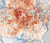
NASA
U.S. temperature anomalies, March, 2012