Launched into space late last month, a new Earth-observing satellite from NASA and the Japan space agency has captured its first images, which show an
extra-tropical cyclone off the coast of Japan at unprecedented resolution. The satellite, called the Global Precipitation Measurement (GPM) Core Observatory, combines two powerful instruments that allow scientists to monitor precipitation around the globe in great detail, as the cyclone image demonstrates. One instrument, the Dual-frequency Precipitation Radar, captured a three-dimensional cross-section of the storm, with the heaviest precipitation shown in red and yellow. The second tool, a GPM Microwave Imager, observed different types of precipitation across a broad swath of the storm. Together, the instruments will help scientists more accurately predict rainfall and calculate how much precipitation falls to the Earth’s surface.
Click to Enlarge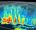
Cyclone cross-section