A team of scientists is enlisting public support to help produce a more comprehensive inventory of carbon dioxide emissions from power plants globally, urging citizens to identify power plants in their communities with a new digital app. While data from some of the 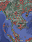 world’s industrialized regions — including the U.S. and Europe — are already widely available, researchers at Arizona State University (ASU) say specific information on carbon emissions from most parts of the world is difficult to obtain. “It turns out that we know far less about fossil fuels than we thought we did,” Kevin Gurney, an emissions modeler at ASU and co-leader of the so-called Ventus Project, told Nature. “We could use some help.” Using a simple Google Earth application, the technology enables users to upload exact coordinates of local power plants, and, if possible, information on the type of fuels used or the quantity of CO2 emissions. Organizers hope that the crowdsourcing initiative will fill data gaps on the world’s roughly 30,000 power plants.
Google Earth