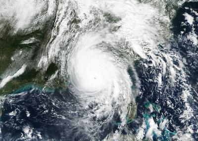
A view of Hurricane Michael after it made landfall in the Florida panhandle on October 10, 2018. NASA/NOAA
It took Hurricane Michael just 24 hours to intensify from a Category 1 storm to a Category 4 before slamming into Florida’s Gulf Coast last October. Similarly, Hurricane Harvey in 2017 went from a Category 2 to a Category 4 in less than a day. This trend of rapid intensification is becoming more common among tropical storms in the Atlantic Ocean, largely due to climate change, according to new research published in the journal Nature Communications.
Between 1982 and 2009, the percentage of Atlantic storms that underwent rapid intensification — technically defined as an increase in wind speed greater than 35 miles per hour in 24 hours — tripled, the study found. “Natural variability cannot explain the magnitude of the observed upward trend,” the scientists wrote. Warm ocean temperatures help to fuel hurricanes; in recent years, parts of the Gulf of Mexico, where most of these storms intensify, have measured as much as 7.2 degrees Fahrenheit above average.
“There’s just a whole host of issues that come along with rapid intensification, and none of them are good,” Jim Kossin, a hurricane expert with the National Oceanic and Atmospheric Administration and a co-author of the study, told The Washington Post. “Rapid intensification is exceedingly dangerous because people… [are] not warned adequately, they’re not prepared, many of them don’t evacuate.”
The Washington Post noted that “the five most destructive Atlantic storms of the past two years all went through rapid intensification,” including Hurricanes Harvey, Irma, Maria, Florence, and Michael.


