‘Atlas of the Real World’
`Atlas of the Real World’
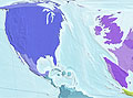
The newly released Atlas of the Real World contains 366 digitally modified maps depicting the nations of the world not by their physical size, but by their demographic importance. The atlas covers a vast range of subjects, ranging from pollution emissions to population growth to forest loss. This image (right) shows the proportional contribution of various countries to the growth of carbon dioxide emissions by 2015.
More From E360
-
MINING
In Coal Country, Black Lung Surges as Federal Protections Stall
-
Biodiversity
Older and Wiser: How Elder Animals Help Species to Survive
-
Climate
Rusting Rivers: Alarm Grows Over Uptick in Acidic Arctic Waters
-
ANALYSIS
A More Troubling Picture of Sea Level Rise Is Coming into View
-
INTERVIEW
Why Protecting Flowering Plants Is Crucial to Our Future
-
OPINION
Trying Times: Keeping the Faith as Environmental Gains Are Lost
-
ANALYSIS
As It Boosts Renewables, China Still Can’t Break Its Coal Addiction
-
OPINION
Can America’s Wolves Survive an Onslaught of Political Attacks?
-
MINING
As Zambia Pushes New Mining, a Legacy of Pollution Looms
-
Biodiversity
Long Overlooked as Crucial to Life, Fungi Start to Get Their Due
-
ANALYSIS
Species Slowdown: Is Nature’s Ability to Self-Repair Stalling?
-
OPINION
Beyond ‘Endangerment’: Finding a Way Forward for U.S. on Climate