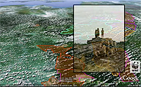
A new animation produced by the group WWF-Indonesia offers a tree-level tour of a biodiversity rich region of Sumatran rainforest targeted for destruction by logging companies. The animation, created using Google Earth, highlights proposed logging efforts in a region known as Bukit Tigapuluh, or “Thirty Hills,” a landscape that is home to endangered Sumatran tigers, elephants, rhinos, and orangutans, and represents one of the last large blocks of untouched forest in the area. While some parts of the region are protected as a national park, a large segment of lowland forest is located outside protected areas and is already concessioned for logging by major logging conglomerates. Google Earth has become an increasingly popular campaign tool for environmental organizations. Groups such as the Amazon Conservation Team and Amazon Watch have used it in efforts to halt illegal logging and the proposed construction of a dam on the Amazon River.
Google Earth Animation Highlights Region Targeted for Logging
More From E360
-
Cities
In Steel Country, the Fight for Clean Air Faces New Obstacles
-
Solutions
Beyond Lithium: New Battery Tech Starts to Break Through
-
INTERVIEW
What Do We Actually Know About the Microplastics Inside Us?
-
Energy
A Home Battery Revolution Is Reshaping the Power Grid
-
Energy
In East Africa, a Controversial Oil Project Is Poised for Production
-
Climate
A Missing Piece in Climate Models: Nature’s Own Emissions
-
INTERVIEW
An EPA Researcher Details the Agency’s Assault on Science
-
Oceans
Efforts to Save Kelp Forests from Ocean Warming Are Ramping Up
-
Biodiversity
Pollution Is Changing the Smells of Nature, With Risks for Wildlife
-
Oceans
Supertrawlers Are Taking Antarctic Krill That Whales Depend On
-
INTERVIEW
The U.S. Senator Who Won’t Shut Up about Climate Change
-
Energy
A First Among Major Nations, India Is Industrializing With Solar