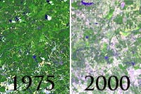
The World Resources Institute has launched a website that maps forests in the southern United States, which produce more pulp for paper than any place on Earth. Using satellite imagery, GoogleEarth technology, and decades of forest data, the site — SeeSouthernForests.org — depicts threats to the region’s forests including pest and pathogen outbreaks, wildfire, logging, and human development, the leading cause of deforestation in the South. About 27 percent of forests in the region are owned by companies and financial institutions, while individuals and families still own about 60 percent. “Surveys indicate that most families want to pass their forests on to the next generation,” said Todd Gartner, manager of Conservation Incentives at the American Forest Foundation. “However, with increasing development pressure, market-based incentives are needed to ensure that private forests remain as forests.” WRI officials hope the new online resource will illustrate the history of these forests, and help landowners better understand how numerous forces are affecting the region.
New Online System Maps Risks to Forests in U.S. South
More From E360
-
Solutions
Beyond Lithium: New Battery Tech Starts to Break Through
-
INTERVIEW
What Do We Actually Know About the Microplastics Inside Us?
-
Energy
A Home Battery Revolution Is Reshaping the Power Grid
-
Energy
In East Africa, a Controversial Oil Project Is Poised for Production
-
Climate
A Missing Piece in Climate Models: Nature’s Own Emissions
-
INTERVIEW
An EPA Researcher Details the Agency’s Assault on Science
-
Oceans
Efforts to Save Kelp Forests from Ocean Warming Are Ramping Up
-
Biodiversity
Pollution Is Changing the Smells of Nature, With Risks for Wildlife
-
Oceans
Supertrawlers Are Taking Antarctic Krill That Whales Depend On
-
INTERVIEW
The U.S. Senator Who Won’t Shut Up about Climate Change
-
Energy
A First Among Major Nations, India Is Industrializing With Solar
-
A NOTE FROM THE EDITOR
After Two Decades, E360’s Founder and Editor Is Moving On