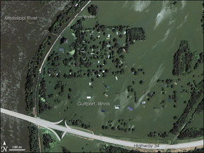
This image, released on NASA’s Earth Observatory site, shows the fate of one of many towns inundated by severe flooding in the American Midwest in June. The tops of roofs and trees are all that are visible in the town of Gulfport, Illinois. The Mississippi River breached the levees, at left, swamping the exit ramps leading into Gulfport. This month’s flooding has been the worst to hit many Midwestern states in decades; some scientists believe that changing land use and farming patterns, which have reduced the ability of the soil and wetlands to absorb heavy rains, have exacerbated the flooding.
The Mississippi Engulfs a Town
More From E360
-
Solutions
Beyond Lithium: New Battery Tech Starts to Break Through
-
INTERVIEW
What Do We Actually Know About the Microplastics Inside Us?
-
Energy
A Home Battery Revolution Is Reshaping the Power Grid
-
Energy
In East Africa, a Controversial Oil Project Is Poised for Production
-
Climate
A Missing Piece in Climate Models: Nature’s Own Emissions
-
INTERVIEW
An EPA Researcher Details the Agency’s Assault on Science
-
Oceans
Efforts to Save Kelp Forests from Ocean Warming Are Ramping Up
-
Biodiversity
Pollution Is Changing the Smells of Nature, With Risks for Wildlife
-
Oceans
Supertrawlers Are Taking Antarctic Krill That Whales Depend On
-
INTERVIEW
The U.S. Senator Who Won’t Shut Up about Climate Change
-
Energy
A First Among Major Nations, India Is Industrializing With Solar
-
A NOTE FROM THE EDITOR
After Two Decades, E360’s Founder and Editor Is Moving On