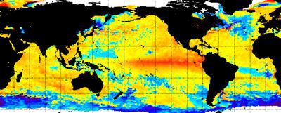
There is a strong chance for another El Niño in the second half of 2017, bringing with it altered weather patterns across the globe that could include drought in parts of Africa, Asia, and South America, and wet conditions in the southern U.S., forecasts from the National Oceanic and Atmospheric Administration and other organizations warned last week.
The new El Niño would start just over a year after the end of one of the world’s strongest El Niños on record. That event, which lasted from 2015 to 2016, increased surface water temperatures in the central Pacific Ocean by as much as 4 degrees Fahrenheit above normal. NOAA scientists did not say how severe the new El Niño could be.
Mike Halpert, deputy director of NOAA’s Climate Prediction Center, told the New York Times that if an El Niño does materialize later this year, the swing from one event to a La Niña and back in such a short time has only happened once, in the 1960s.
“If you just look at the current state of the ocean and the atmosphere, it doesn’t really look like what we typically expect to see as we head into El Niño,” he said. “There’s been a little bit of head scratching.”


