“Will we still be here in 30, 40, or 50 years?,” says Superintendent Hallac. “All I know is it will different, maybe very different.”
Hallac put out an all-hands call and scores of Park Service employees and volunteers arrived with rakes, shovels, and trash bins. The federal agency purchased a $40,000 mechanical rake to sweep up the debris. Hallac’s makeshift army hauled away 70 truckloads of waterlogged insulation, siding, and drywall from one collapse. “It’s not something we want to do or any of us probably thought of when we joined the Park Service,” the 50-year-old biologist by training wryly noted.
These days climate-related issues are creating an array of unanticipated challenges for the nation’s 10 national seashores, from Massachusetts to Northern California. At Cape Cod and Point Reyes, towering dunes and sea cliffs are eroding as a result of rising seas and thrashing surf. Sea level rise and shoreline shifts are also considered threats to wildlife at pristine Cumberland Island National Seashore in southern Georgia. Meanwhile, along Gulf Islands National Seashore in Florida and Mississippi, rising water, more intense storms, and erosion are a constant threat, federal reports show.
In addition to their traditional roles as stewards of some of the last undeveloped shorelines in the United States, superintendents of the seashores now find themselves wrestling with the intensifying impacts of climate and weather changes. Billions of dollars-worth of assets are at risk, according to a 2015 study by the U.S. Department of Interior, including historic lighthouses, visitors’ centers, staff housing, parking lots, hiking trails, and marinas. The accelerating impacts are also threatening the future of the seashores themselves.

Left: A collapsed house in Rodanthe, North Carolina, in March. Right: Hallac (second from right) and volunteers clear house debris in February 2022. National Park Service
“Will we still be here in 30, 40, or 50 years?” Hallac mused during a recent tour of Cape Hatteras. “All I know is that it will be different, maybe even very different.”
No park may face a more daunting future than Cape Hatteras National Seashore. America’s first federal seashore, authorized by Congress in 1937, it includes miles of perpetually shifting shoreline, scrubby, windblown interior sand flats, and vast salt marshes that serve as spawning grounds for fish and crabs, as well as providing habitat for migrating birds and waterfowl. Beginning near the booming tourist resort of Nags Head in the north, the Seashore extends nearly 70 miles to the isolated village of Ocracoke in the south. It is bordered by the Atlantic Ocean and by the Pamlico Sound, the second-largest estuary in the U.S.
The geology of the Seashore is unique, notes Robert S. Young, director of the Program for the Study of Developed Shorelines at Western Carolina University. It has little elevation in many places and has lost hundreds of feet in shoreline from erosion, threatening the only highway on and off of the islands.

Yale Environment 360
“We are basically talking about a low-lying sandbar,” said Young, “a highly dynamic complex of barrier islands.” The shoreline is always in motion, flushed by currents and waves, vulnerable to storms and hurricanes, and is longer, lower, and farther at sea (Hatteras Village is nearly 30 miles from the mainland) than most other barrier islands on the East and Gulf Coasts.
According to the National Oceanic and Atmospheric Administration (NOAA), the waters surrounding the Seashore have risen by about one foot in the last century, and are projected to lift by another 10 to 14 inches by 2050. “That’s just 27 years from today,” Hallac said, pausing by a NOAA gauge near a marina in the Seashore. “It is very scary. We, including myself, need to have a sense of urgency.”
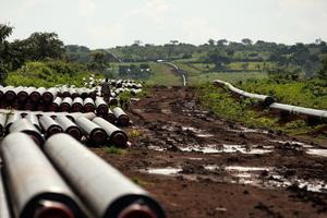
Michael J. Flynn, a physical scientist for the Park Service who works closely with Hallac, has been conducting vulnerability assessments and planning for the Seashore’s future. He has identified low-lying maintenance facilities and staff housing that will likely be swamped within five to 10 years, and need to be either torn down or moved. Several parking lots being undermined by Pamlico Sound may also need to relocated or elevated. In 2019, the north end of Ocracoke Island was severely breached by Hurricane Dorian, destroying a large swath of the only highway and threatening a critical ferry dock. State officials are studying the feasibility of moving the dock to a less vulnerable location. But the cost could be over $100 million dollars, Hallac said.
These threats — rising water, floods, storms, hurricane force winds — wouldn’t have as much of an impact if Cape Hatteras were like most national parks. But the Seashore is different. For one, it was designed around eight small villages that already existed when it was authorized in 1937. A few thousand hardy people fished or grazed cows, goats, and pigs on the beach and marsh.
By 1953, when the Seashore opened, the economy of the Outer Banks was rapidly shifting from fishing to real estate and tourism. In order to win acceptance from the villagers, Park Service officials promoted the tourism trade and stressed that it would create thousands of jobs and pump up local real estate values.

Waves encroach on a house in Rodanthe, North Carolina in January 2023, near a portion of Highway 12 closed due to erosion. Jahi Chikwendiu / The Washington Post via Getty Images
Indeed, as the number of annual Seashore visitors has climbed from a few hundred thousand to about 3 million, in 2021, the economy and landscape of the villages have been reshaped. Along with the tourists have come more and bigger rental houses, commercial strip outlets, restaurants, cars, trash, and pollution. “More of everything,” says Hallac. “More human impacts.” The Seashore is no longer just a seashore. It is now also a busy summer playground.
Early on, Park Service officials made two other promises that helped transform the Seashore. First, they endorsed the controversial idea of building a state highway through the park. Second, they assured villagers that they would do everything in their power to control erosion and restore the island to its original, natural condition.
The promises would prove to be both costly and contentious. For example, what did leaders mean by natural condition? Did they mean the way the Seashore looked hundreds of years ago when the first European visitors arrived on the Outer Banks? Or did they mean a more modern, engineered version of the Seashore? After all, the barrier island had been dredged, bulldozed, and manipulated by humans for years. During the New Deal, workers from the Works Progress Administration and Civilian Conservation Corps had built a towering 100-mile-long artificial sand dune meant to control erosion and block waves from washing over the islands.

An aerial view from the south end of Hatteras Island. National Park Service
Between 1958 and 1972, the Park Service spent more than $10 million widening beaches, repairing sand dunes, and erecting miles of sand fence. It even paid for airplanes to spread fertilizer over the dunes to hold grass and other vegetation in place.
Relations between the villagers and Seashore officials remain tricky at times. “I always try to be transparent,” says Hallac, who oversaw research teams at Everglades and Yellowstone national parks before taking over as superintendent at Cape Hatteras in 2014. “They may not always like what I have to say, but I think they respect that I am open.”
“There are strong local constituencies that are very engaged in what the Seashore is doing,” says Western Carolina’s Young. “It makes managing the park a very delicate balance.”
In early June, Hallac and Flynn took a writer to see the two-mile stretch of heavily eroding shoreline in Rodanthe where five houses have fallen into the ocean since 2020. Nearly a dozen other homes had been tagged by Dare County officials as unlivable, often because of damaged septic systems in or near the surf zone. Hallac noticed one system with its concrete lid half-off and a broken PVC pipe that had spewed a trail of toilet paper and what appeared to be human effluent near the ocean. The shoreline in front of the house belonged to the Park Service. “That’s going onto the National Seashore,” he said.

Waves top sand bags along Cape Hatteras National Seashore on Ocracoke Island. National Park Service
The area is dotted with subdivisions with names like Mirlo Beach, Ocean Trails, and South Shore. The nearby shoreline has been eroding for over a century, records show, with some areas having lost over 100 feet or more. Houses that used to have wide beaches now squat in the water at high tide.
Hallac participated in a series of meetings with property owners to discuss what, if anything, could be done to protect the area. The owners wanted government officials to pump huge volumes of sand in front of their houses. Dare County Manager Bobby Outten explained that the county didn’t have the funds. A subsequent study found that it would cost as much as $40 million to widen the beach and up to $175 million to maintain it for approximately 15 years.
Young and his Western Carolina colleagues then produced a study saying that it would be far cheaper for the county to buy some of the threatened properties than to do an expensive beach nourishment project. Using current property values, the researchers estimated that it would cost $43 million to buy the selected properties, leaving owners with a beach they could use for 15 to 25 years.
Hallac questions whether there is the political will or enough money to fund a large-scale buyout program. But he does think selective buyouts may work. He has approached his bosses at the Interior Department with a proposal to buy two threatened Rodanthe houses. Meanwhile, about a half-dozen other owners with large enough lots have moved their houses farther inland.
The Seashore may be close to a tipping point, Hallac says. The question now is whether humans will continue to try to hold the line to protect billions of dollars in investments, or allow nature to take its course.
“It is a seashore that has been highly altered by humans, with many unintended consequences,” the superintendent says. “It is part of a larger philosophical story: Are we going to play God with our national parks, or trust nature and natural processes?”