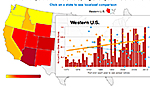
An interactive tool produced by the group Climate Central illustrates how rising temperatures and reduced snowpack in the western U.S. have corresponded with an increase in wildfiresin recent decades. Based on
federal wildfire data from 1970 to 2012, the graphic shows how large fires in some western states — including Arizona, Colorado, and Idaho — have doubled or even tripled in four decades, a period when the average spring and summer temperatures in 11 states increased by more than 1.5 degrees F. According to the Climate Central analysis, Arizona has experienced the highest average increase in spring temperatures, about 1 degree F, which has likely been a key factor in the steep increase in fires covering more than 1,000 acres. Another key factor has been the decrease in mountain snowpack. During several seasons, unusually low amounts of spring snow caused extended droughts that helped drive more big fires.
Map Shows Possible Link Between Warmer Springs and Large Fires
More From E360
-
Energy
Why U.S. Geothermal May Advance, Despite Political Headwinds
-
Food & Agriculture
In War Zones, a Race to Save Key Seeds Needed to Feed the World
-
Climate
Lightning Strikes the Arctic: What Will It Mean for the Far North?
-
RIVERS
A Win for Farmers and Tribes Brings New Hope to the Klamath
-
Solutions
Deconstructing Buildings: The Quest for New Life for Old Wood
-
NATURAL DEFENSES
How Restored Wetlands Can Protect Europe from Russian Invasion
-
Solutions
Birds vs. Wind Turbines: New Research Aims to Prevent Deaths
-
FORESTS
Cambodian Forest Defenders at Risk for Exposing Illegal Logging
-
OPINION
The ‘Green’ Aviation Fuel That Would Increase Carbon Emissions
-
CONSERVATION
Out of the Wild: How A.I. Is Transforming Conservation Science
-
Energy
China’s Mega Dam Project Poses Big Risks for Asia’s Grand Canyon
-
Solutions
How Natural Solutions Can Help Islands Survive Sea Level Rise