A coalition of scientists and environmental advocacy groups has developed a camera-equipped drone they say could become a key conservation tool for monitoring
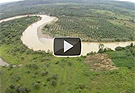
forest loss and endangered wildlife. The coalition — which includes The Orangutan Conservancy, the Denver Zoo, and two Swiss scientists — has already deployed a remote-control drone to map deforestation and count orangutans in the remote forests of North Sumatra in Indonesia, according to a report in Mongabay. The drone, which was developed by ecologist Lian Pin Koh at ETH Zürich, is able to travel a pre-programmed flight route and take aerial photos and video footage. During 30 flights so far, it has collected hundreds of photos and hours of video, including images of oil palm plantings along the edge of a river.
Conservationists Launch Drone To Monitor Forest Loss and Wildlife
More From E360
-
Energy
A Home Battery Revolution Is Reshaping the Power Grid
-
Energy
In East Africa, a Controversial Oil Project Is Poised for Production
-
Climate
A Missing Piece in Climate Models: Nature’s Own Emissions
-
INTERVIEW
An EPA Researcher Details the Agency’s Assault on Science
-
Oceans
Efforts to Save Kelp Forests from Ocean Warming Are Ramping Up
-
Biodiversity
Pollution Is Changing the Smells of Nature, With Risks for Wildlife
-
Oceans
Supertrawlers Are Taking Antarctic Krill That Whales Depend On
-
INTERVIEW
The U.S. Senator Who Won’t Shut Up about Climate Change
-
Energy
A First Among Major Nations, India Is Industrializing With Solar
-
A NOTE FROM THE EDITOR
After Two Decades, E360’s Founder and Editor Is Moving On
-
Solutions
Restoring the Flow: A Milestone in the Revival of the Everglades
-
Climate
Why Fears Are Growing Over the Fate of a Key Atlantic Current