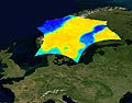
The European Space Agency has published the first results from a satellite-based mission it says will help scientists better understand the Earth’s water cycle. Using so-called “brightness temperature” images collected from space — a measurement of the radiation emitted from Earth’s surface — researchers are able to calculate how much moisture is in the top layers of soil, and how much salt is present at the ocean’s surface. High brightness temperatures reflect dry soils and low brightness temperatures represent heavy moisture, which is why bodies of water show up as cold spots. In addition to providing valuable information on the relationship between the planet’s surface and the atmosphere, data from the Soil Moisture and Ocean Salinity project will help scientists better model weather and climate changes, ESA officials predict. The information may also be applied to agriculture and water resource management. The satellites were launched in November.
ESA Satellite Mission Provides New Understanding of Planet’s Water Cycle
More From E360
-
Climate
How Climate Risks Are Putting Home Insurance Out of Reach
-
INTERVIEW
Inside the Plastics Industry Playbook: Delay, Deny, and Distract
-
Biodiversity
Freeing Captive Bears from Armenia’s Backyards and Basements
-
Food & Agriculture
In Indonesia’s Rainforest, a Mega-Farm Project Is Plowing Ahead
-
FILM CONTEST WINNER
In the Yucatan, the High Cost of a Boom in Factory Hog Farms
-
INTERVIEW
In the Transition to Renewable Energy, China Is at a Crossroads
-
E360 Film Contest
In India, a Young Poacher Evolves into a Committed Conservationist
-
E360 Film Contest
The Amazon Rainforest Approaches a Point of No Return
-
Biodiversity
Shrinking Cod: How Humans Are Impacting the Evolution of Species
-
Cities
‘Sponge City’: Copenhagen Adapts to a Wetter Future
-
INTERVIEW
On Controlling Fire, New Lessons from a Deep Indigenous Past
-
Solutions
Paying the People: Liberia’s Novel Plan to Save Its Forests