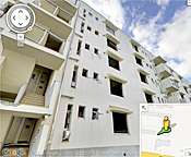
As part of an ongoing project to digitally archive the aftermath of the 2011 tsunami in northeastern Japan, Google has published several new panoramic images that provide a sobering glimpse of the widespread
devastation in communities across the region. The images, taken with the company’s Street View technology in four cities in the TÅhoku region, allows users to take a virtual tour of seriously damaged buildings before they are demolished. One panoramic view of a public housing project illustrates the height of the tsunami wave, which ruined everything up to the fourth floor of the building. Another image, of the condemned Ukedo Elementary School, shows the collapsed auditorium floor beneath the banner of a graduation ceremony that was never held. The images were added to Google’s “Memories for the Future” website, which is chronicling the affected areas from before and after the tsunami.
Google Images Document Devastation of 2011 Tsunami in Japan
More From E360
-
Biodiversity
‘Wastelands’ No More: India Charts a Future for Its Grasslands
-
Climate
After Decades of Drought, Water Is Rising in the African Sahel
-
Cities
In Steel Country, the Fight for Clean Air Faces New Obstacles
-
Solutions
Beyond Lithium: New Battery Tech Starts to Break Through
-
INTERVIEW
What Do We Actually Know About the Microplastics Inside Us?
-
Energy
A Home Battery Revolution Is Reshaping the Power Grid
-
Energy
In East Africa, a Controversial Oil Project Is Poised for Production
-
Climate
A Missing Piece in Climate Models: Nature’s Own Emissions
-
INTERVIEW
An EPA Researcher Details the Agency’s Assault on Science
-
Oceans
Efforts to Save Kelp Forests from Ocean Warming Are Ramping Up
-
Biodiversity
Pollution Is Changing the Smells of Nature, With Risks for Wildlife
-
Oceans
Supertrawlers Are Taking Antarctic Krill That Whales Depend On