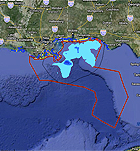
The U.S. government this week launched an interactive resource that allows the public to follow developments in the BP oil spill and ongoing response efforts in “near-real-time.” Originally designed as a way to keep participants in the vast clean-up effort informed, the GeoPlatform uses the latest information from various federal, state, and local organizations to track the spill’s path, identify closed fishing areas and threatened coastal zones, and to map the latest response efforts. Numerous agencies, including the U.S. Coast Guard and the Environmental Protection Agency, post data on a common server. The site was created by the National Oceanic and Atmospheric Administration and the University of New Hampshire’s Coastal Response Research Center. “This Web site provides users with an expansive, yet detailed geographic picture of what’s going on with the spill,” Jane Lubchenco, NOAA administrator, said in a statement. Several weeks ago, the government launched another site, deepwaterhorizonresponse.com, to provide updates on spill response and the latest news.
Interactive Resource Tracks Gulf Spill Response in Near Real-Time
More From E360
-
Solutions
Plagued by Flooding, an African City Reengineers Its Wetlands
-
WATER
After Ruining a Treasured Water Resource, Iran Is Drying Up
-
FILM
At a Marine Field Station, Rising Seas Force an Inevitable Retreat
-
Energy
To Feed Data Centers, Pennsylvania Faces a New Fracking Surge
-
SPACE
Scientists Warn of Emissions Risks from the Surge in Satellites
-
WILDLIFE
A Troubling Rise in the Grisly Trade of a Spectacular African Bird
-
MINING
In Myanmar, Illicit Rare Earth Mining Is Taking a Heavy Toll
-
INTERVIEW
How Batteries, Not Natural Gas, Can Power the Data Center Boom
-
ANALYSIS
As U.S. and E.U. Retreat on Climate, China Takes the Leadership Role
-
Solutions
From Ruins to Reuse: How Ukrainians Are Repurposing War Waste
-
ANALYSIS
Carbon Offsets Are Failing. Can a New Plan Save the Rainforests?
-
Energy
Facing a Hostile Administration, U.S. Offshore Wind Is in Retreat