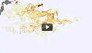
A new animation developed by researchers at the University of Hawaii’s International Pacific Research Center illustrates the likely path of the spreading field of debris caused by retreating waves from last year’s gigantic tsunami in Japan. The model —
based on satellite data and a network of scientific buoys showing sea surface height, ocean surface winds, and ocean currents — shows that debris swept into the Pacific by the event now likely stretches across an area covering 5,000 kilometers by 2,000 kilometers. Much of the debris was initially pulled by the strong Kuroshio Current, which travels past eastern Japan before shifting east and then into the North Pacific Current. The Japanese government estimates about 5 million tons of debris was pulled into the ocean; about 70 percent sank to the seafloor, with about 1.5 million tons still floating.
Model Shows Debris Field In Pacific From Japanese Tsunami
More From E360
-
Energy
Why U.S. Geothermal May Advance, Despite Political Headwinds
-
Food & Agriculture
In War Zones, a Race to Save Key Seeds Needed to Feed the World
-
Climate
Lightning Strikes the Arctic: What Will It Mean for the Far North?
-
RIVERS
A Win for Farmers and Tribes Brings New Hope to the Klamath
-
Solutions
Deconstructing Buildings: The Quest for New Life for Old Wood
-
NATURAL DEFENSES
How Restored Wetlands Can Protect Europe from Russian Invasion
-
Solutions
Birds vs. Wind Turbines: New Research Aims to Prevent Deaths
-
FORESTS
Cambodian Forest Defenders at Risk for Exposing Illegal Logging
-
OPINION
The ‘Green’ Aviation Fuel That Would Increase Carbon Emissions
-
CONSERVATION
Out of the Wild: How A.I. Is Transforming Conservation Science
-
Energy
China’s Mega Dam Project Poses Big Risks for Asia’s Grand Canyon
-
Solutions
How Natural Solutions Can Help Islands Survive Sea Level Rise