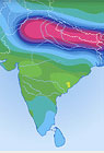
A pair of satellites that measures changes in the earth’s gravity has shown that the intense irrigation of a 1,200-mile swath of northern India is depleting groundwater at a rate of 1.5 to 4 inches per year. The satellites, part of a joint U.S.-German mission known as GRACE (Gravity Recovery and Climate Experiment), show that the region — inhabited by 600 million people heavily dependent on irrigated agriculture — is withdrawing 13 cubic miles of water per year from underground aquifers. Reporting in the journal Geophysical Research Letters, U.S. and Indian scientists analyzed satellite data from 2002 to 2008 and concluded that Indian farmers are pumping out groundwater 70 percent faster than estimated by the Central Ground Water Board of India in the 1990s. The GRACE satellites, orbiting in tandem and flying roughly 135 miles apart, use sophisticated instruments to detect changes in the earth’s gravitational pull, mainly due to water moving on or under the surface. The satellites, which have been used to measure the rapid thinning of ice sheets in the Arctic, “can help regional water managers by giving them a holistic view” of major aquifers, according to James Famiglietti, a University of California hydrologist who worked in the Indian project.
Satellite Data Confirm Rapid Depletion of Indian Groundwater
More From E360
-
Solutions
From Ruins to Reuse: How Ukrainians Are Repurposing War Waste
-
ANALYSIS
Carbon Offsets Are Failing. Can a New Plan Save the Rainforests?
-
Energy
Facing a Hostile Administration, U.S. Offshore Wind Is in Retreat
-
Biodiversity
As Jaguars Recover, Will the Border Wall Block Their U.S. Return?
-
WATER
An E.U. Plan to Slash Micropollutants in Wastewater Is Under Attack
-
INTERVIEW
This Data Scientist Sees Progress in the Climate Change Fight
-
Climate
As Floods Worsen, Pakistan Is the Epicenter of Climate Change
-
Climate
Heat Stress Is a Major Driver of India’s Kidney Disease Epidemic
-
Energy
It’s a ‘Golden Age’ for U.S. LNG Industry, But Climate Risks Loom
-
Climate
How Climate Risks Are Putting Home Insurance Out of Reach
-
INTERVIEW
Inside the Plastics Industry Playbook: Delay, Deny, and Distract
-
Biodiversity
Freeing Captive Bears from Armenia’s Backyards and Basements