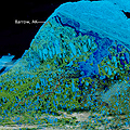
This false-color satellite image released by NASA shows the re-emergence of hundreds of ponds scattered across the tundra of Alaska’s North Slope after the winter snows disappeared in early June. The region depicted in the image is roughly 250 kilometers (155 miles) across and is located south of Barrow. The image vividly illustrates just how much of the Arctic tundra is made up of ponds and small lakes, which often form because melting snows are unable to penetrate more than a foot or two into the earth because the permafrost below is frozen year-round. The relative flatness of the terrain also slows drainage and promotes the formation of ponds and lakes. As the climate warms, the permafrost is beginning to thaw in many areas, leading to the draining of some lakes. In other areas, however, the layer of permafrost is actually thickening. Overall, soil temperatures in Arctic tundra are rising, leading to increased release of methane, a powerful greenhouse gas.
Spring Thaw on the North Slope
More From E360
-
Energy
A Home Battery Revolution Is Reshaping the Power Grid
-
Energy
In East Africa, a Controversial Oil Project Is Poised for Production
-
Climate
A Missing Piece in Climate Models: Nature’s Own Emissions
-
INTERVIEW
An EPA Researcher Details the Agency’s Assault on Science
-
Oceans
Efforts to Save Kelp Forests from Ocean Warming Are Ramping Up
-
Biodiversity
Pollution Is Changing the Smells of Nature, With Risks for Wildlife
-
Oceans
Supertrawlers Are Taking Antarctic Krill That Whales Depend On
-
INTERVIEW
The U.S. Senator Who Won’t Shut Up about Climate Change
-
Energy
A First Among Major Nations, India Is Industrializing With Solar
-
A NOTE FROM THE EDITOR
After Two Decades, E360’s Founder and Editor Is Moving On
-
Solutions
Restoring the Flow: A Milestone in the Revival of the Everglades
-
Climate
Why Fears Are Growing Over the Fate of a Key Atlantic Current