“Every drip of what’s coming out of those trucks: hazardous waste, fracking fluids, not to mention spills at every fueling lane of diesel, axle grease, transmission fluids,” he said in a penetrating North Texas twang, “the first flush during a rain, it all goes through the drains and into that concrete flume.”
He pointed beyond the chain link fence, off the truck stop property. “That flume goes right to the river and dumps it all in the water. Never touches land.”
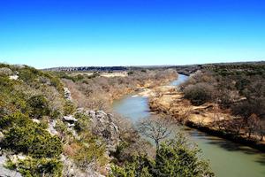
The town of Junction gets its name from the nearby confluence of the North and South Llano River. From there the emerald waters of the Llano proper flow 100 miles through a mosaic of mesquite and cedar, rocky outcrops, and open rangeland. It then runs right into Texas’s Colorado River to form Lake Lyndon B. Johnson, one of six reservoirs built to manage floods and sustain Austin’s water supply. But Neiman and others upstream think of the river as a gem of Texas Hill Country — a wild and scenic river, but without Wild and Scenic River status.
In fact, in Texas, only a 196-mile section of the Rio Grande in the Big Bend benefits from the federal protection warranted through the 1968 Wild and Scenic River Act. The other nearly 191,000 miles of Texas waterways are potentially subject to the demands of private enterprise: sand mines, dams, fracking, private wells, and so on.
Or, in the case of the Llano, a concrete flume that delivers effluent to the flowing river.

The Pilot Flying J truck stop on the banks of the North Llano in Junction, Texas. Courtesy of Austin Price
In 2014, Tennessee-based Pilot Flying J built this truck stop on the banks of the North Llano, despite protest from Neiman and other local residents. Construction crews cleared riparian grasses and scraggly oaks as Neiman delved into Texas’ convoluted river policy and wrote a complaint to the Texas Commission on Environmental Quality. This wasn’t the first time Neiman, a native grasses and flower seed farmer, had tried to run private development off his local public river. In 1999, he sued a sand and gravel company called Weirich Brothers, Inc. for increasing turbidity in the river near downtown Junction. As a result, the company packed up their dredge lines and bulldozers and moved to another site, another Texas river.
This time, Neiman’s complaint fell on deaf ears. “This all came from the top down,” he said, claiming that the CEO of Pilot Flying J, Jimmy Haslam, has close ties to the Republican Party, which had seemed to give the $13 billion company an immunity from the red state’s environmental review process.
But this treatment of Texas rivers isn’t unique to Pilot Flying J. Nor is it unique to the Llano. In fact, as far as Texas rivers go, the Llano has managed to escape a lot of the stress of human impact that many rivers in the state face, such as the Brazos and Trinity rivers that flow through the state’s urban triangle — an urbanizing region of the state boxed in between Houston, Dallas, and San Antonio. Even in the 1950s, when the writer John Graves paddled his canoe down the Brazos, he could foresee how ambiguous boundaries between private development and public rivers would cause local waterways to fall through the cracks of environmental protection. “Maybe you save a Dinosaur Monument from time to time,” he wrote in his 1959 Goodbye to a River, “but inbetween such salvations you lose 10 Brazoses.”
As the public Llano flows its 100 miles through private-property Texas, who’s looking out for one of the state’s last wild rivers?
The Llano isn’t a mighty Western river by any means. But I’ve grown attached to it. I got married on its riverbank, and when I lived in Austin I considered it a respite from the city’s Barton Creek and a reminder of wilder rivers in wilder places. But beyond that, the Llano River is home to numerous species of bass, gar, armadillos, rattlesnakes, and migrating monarch butterflies — as well as to farmers like Neiman who live off the river, grow crops with its water, and care for its banks.
But the Llano is an abused river, as Neiman showed me. It’s public property taken advantage of by private business and landowners through ambiguous environmental protections. And these damages are often unseen by the public.
As per Graves, save a Big Bend from time to time, but in between you lose a Llano. The question is: As the public Llano flows its 100 miles through private-property Texas, who’s looking out for one of the state’s last wild rivers?
A few weeks later, I met Tyson Broad, the watershed coordinator at Texas Tech University’s Llano River Field Station, for lunch in downtown Mason. “I respect property rights,” he told me between bites of his Reuben. “But there’s private property and there’s public property. A lot of people only respect private property rights. Rivers of this state, they belong to everybody.”
Our table overlooked the main street that runs through town. Broad explained how from downtown Mason, 100 miles due west of Austin and a crossroads between the fracking grounds at Permian Basin to the west and the Eagle Ford Shale to the south, you wouldn’t know that the Llano flows through some of its most iconic geography just a few miles away. There, the river widens and winds through limestone bluffs spotted with ashe juniper and prickly pear hanging onto gritty soil atop sandstone bluffs. Beyond those bluffs, the land opens up to rolling hills spotted with spring-green mesquite and deeply rooted live oaks.
But in Mason, the town square buzzes with a West Texas industrial energy. Broad and I talked over the clatter of semis that barreled through town on the abnormally wide main street. “What is that?” Broad said at one point, almost to himself, as a series of trucks sped closely past, carrying oversized hauls of fracking pumps and cylindrical tanks.

Bill Neiman, a local farmer, has fought to protect the Llano from further development. Courtesy of Austin Price
The river takes second place to the boomtown mentality in this town and others like it in Central Texas. But Broad’s trying to change that, or at least change some of the status quo land management practices that threaten the river.
In 2016, Broad co-wrote a Watershed Protection Plan with another researcher at the field station named Tom Arsuffi. The plan lays out concerns with current land management practices, such as the adverse effects on riparian habitat, wildlife, groundwater levels, and so on, and offers recommended actions for better managing riverbanks. Since nearly all of the land along the Llano is privately owned, the plan’s key audience is landowners. For that reason, direct references to climate change are glaringly absent, and of course, the plan isn’t a regulatory document.
Even so, the strategy hasn’t been met with complete receptivity. “When word had gotten around that this research was funded by the EPA, ranchers came to the station extremely skeptical of the Watershed Protection Plan,” Arsuffi told me when I visited him at the Llano River Field Station. “They thought it was a conspiracy for the federal government to come in and take their lands. I had to explain to them what the plan involves. There would not be any regulations. It would be all stakeholder-driven.”
But although Broad and Arsuffi’s plan isn’t policy, there are laws in Texas that are supposed to protect public waterways like the Llano, though these laws are ambiguous at best.
According to an online Texas River Guide published by the state’s Parks and Wildlife Department, a navigable river that flows through private land is deemed public up until the gradient boundary, which has been defined by the Texas Supreme Court as “located midway between the lower level of the flowing water that just reaches the cut bank and the higher level of it that just does not overtop the cut bank.”
This definition seems to assume that a cut bank doesn’t change with erosion, or even with human alteration. The River Guide goes on to admit that “it is often difficult to determine … where the boundary lies between [public water] and the adjacent private property.” It then suggests, almost sarcastically, that if we really wanted to understand land allocation along public waterways, we should next “bone up on the real estate laws of 19th century Spain and pick up some advanced land surveying techniques, and you will be on your way to becoming an expert.”
There is no clear boundary between private land and a public river — with the favor of ambiguity tipping toward private developers.
In other words, there is no clear boundary between private land and a public river — with the favor of ambiguity tipping toward private developers. And even if the gradient boundary were clearly defined, some landowners don’t always abide by the rules.
Across from the field station, Arsuffi drove me in a golf cart down to the Llano, passing his riparian restoration projects — tangles of saplings and grasses in fenced-in enclosures to keep out invasive axis deer and other species — before reaching a viewpoint. Just across the river, about 20 feet wide here, Arsuffi pointed out evidence that a bulldozer had cleared a path to the river, taking out the cut bank and vegetation and leaving behind about a quarter-acre of overturned gravel. “About a month ago, the guy that owns this property wanted to create access to the river,” said Arsuffi. “It was a cut bank, they just mowed it all down. Illegally.” He showed me bulldozer tracks that had certainly crossed the gradient boundary, clearcutting riparian habitat — all within view of the creators of the Watershed Protection Plan.
Neiman blames absentee landowners who own land along the Llano but reside in the city. “A thing that comes with these landowners is clearing all the way to the water’s edge and making it look like a lawn, bringing in exotic seeds like Bermuda grass, like they’re in Dallas,” he said. “They come to the country and immediately start making it look like the city.”
Other practices are less imposing but just as harmful, if not more so. While surface water belongs to the state of Texas, groundwater belongs to the landowner, as governed by Texas’s rule of capture. This common law grants landowners the right to pump and capture the water beneath their property, regardless of the effects on neighboring wells or neighboring rivers.
“The rule of capture has often been called the law of the biggest pump,” writes Texas A&M natural resource law expert Ronald Kaiser. “And under that rule, Texas springs will continue to go dry.”
Neiman told me a common saying in Texas: if everyone were to withdraw the water they are entitled to by law, then Texas rivers would immediately go dry. In other words, the state’s water policy has overpromised how much water there actually is in some regions.

Sandstone bluffs along the Llano River in Mason County, Texas. Leaflet / Wikimedia Commons
The only thing saving rivers from that fate is not a governing policy or protection plan. Ironically, it’s the fact that landowners are absentee. They simply aren’t there to overdraw water.
Nearly half of the land around Junction is owned by absentee landowners, a trend that started with the mid-1990s collapse of the livestock industry in this part of Texas and continued as parcels of land were fragmented and sold. This land fragmentation has two effects on the watershed. First, there are fewer people on the land, which may suggest less human impact. Much of the landscape has begun to change, to rewild, without constant human habitation. Coyotes and other predators have begun to return. Unused wells leave the water in the watershed to continue on down to the next stakeholder.
But Neiman laments that with an increase in absentee landownership comes a disconnect from the idea that a river is home to its inhabitants — a relationship that some might call “stewardship” but what conservationist Aldo Leopold said best when he spoke of a “land community.” “You gotta have a certain tenacity to look after this river,” said Neiman, “and that comes with having a local stake in it.”
Unless you’re a riverside landowner like Neiman, it’s hard to find a sense of place on a public river that’s surrounded by inaccessible private land. This is a problem across the state. Ninety-five percent of land in Texas belongs to private landowners. Much of the remaining 5 percent lies in the Big Bend region or other parts of West Texas, 500 miles or more from where most of the state’s population resides.
The Llano River belongs to a public that’s never seen it. We own it, but how do we care for it? How do we find land community with a river surrounded by private property that no one lives on? How do Texans even know that they should care for this river, when it’s been masked by vague protections, its value outstripped by a $13-billion dollar truck stop chain and development up and down its gradient boundary?
“It’s not like I’m against truck stops. But I sure wouldn’t put one right on a river, particularly if it was one of the last clean rivers [in the state].”
“I get it. I actually have two or three 18-wheelers myself. You gotta have ‘em. It’s not like I’m against truck stops,” said Neiman as he walked through the open gate of the chainlink fence on the edge of the Pilot Flying J property. “But I sure wouldn’t put one right on a river, particularly if it was one of the last clean rivers [in the state].”
He carefully slipped down the yellow lichen-covered incline of the concrete flume to a trickling stream at the bottom. The water was opaque, with streaks of greasy rainbow. A discarded car power inverter lay half-submerged. “But I really wouldn’t even put this in a dirty river,” Neiman said. “Kids know this isn’t right.”
The hiss of hydraulics overhead, we followed the concrete STR to the end of the flume. The runoff dripped into the mud of a cleared bank. Just beyond the flume’s reach, the waters of the North Llano babbled in marshy channels. There’s no telling where the gradient boundary would be on this ever changing, human altered riverbed.
A single axis doe burst from the brush ahead, startled from her original path into the concrete channel. Neiman and I watched her struggle up the other side of the flume, hooves slipping on the oil-slicked lichen. Some of the impact we have on wild places is subtler than others. We turned back to Neiman’s pickup, parked next to so many others beneath the tallest artificial structure in the town of Junction: a flashing sign of green and red lights against a darkening sky. DIESEL, $2.95/gallon.
The Young Writers Awards, presented by Yale Environment 360 and the Oak Spring Garden Foundation, honor the best nonfiction environmental writing by authors under the age of 35. Entries for 2020 were received from six continents, with a prize of $2,000 going to the first-place winner. Read all the winners here.