
The author traveled the upper and middle portions of the Rio Grande in Colorado and New Mexico. Yale Environment 360
The concern of Snyder and others is that much of the Rio Grande River — already greatly compromised by channelization, dams, and irrigation — is on a trajectory to disappear and take out the bosque forests, fish, and other creatures that live in it and along it. “We’re past the point of easy answers,” she says.
Flowing out of the Colorado Rockies, the Rio Grande streams from south-central Colorado through New Mexico and on to form the boundary between Texas and Mexico, before emptying into the Gulf of Mexico nearly 1,900 miles later. Increasingly, the Rio Grande’s fate is tied with the impacts of climate change. New Mexico, like much of the West, has been in the grips of unusually hot and dry weather for 20 years. In the past century, the average temperature has risen more than 2 degrees F, with a notable increase in the number of extremely hot days and warm nights.
The Calf Canyon/Hermits Peak Fire burning this year is the largest in the state’s history. Wildfires have been coming earlier and more often, and according to the National Oceanic and Atmospheric Administration (NOAA), “historically unprecedented warming is projected to increase during this century.”
For many in New Mexico, climate warming has clearly arrived.
“I went hiking in a place I usually go, at 10,000 feet, and the aspen are not leafing out. The moss has dried up, and there are dead and downed trees,” said Laura Paskus author of At the Precipice: New Mexico’s Changing Climate. “Seeing it like that in mid-May, even for someone like me who pays attention to climate change, is scary and shocking.”
In the last few years, I have been writing about the impact of the worst drought in the West in more than a millennium on the rivers of the Southwest. I have traveled the length of the Colorado River and the Gila River, which is located in New Mexico and Arizona.
Working with photographer Ted Wood, we set out to see what was happening on the Rio Grande. We started at its headwaters in Colorado’s San Juan Mountains and then followed the upper and middle portions of the river, driving nearly 500 miles to where the Rio Grande dried up, near Las Cruces, New Mexico.

South of Elephant Butte Dam in New Mexico, the Rio Grande is dry for most of the year, and farmers pump groundwater for their fields.
The Rio Grande was once a perennial river, though marked by periods of extreme drought and dotted by dry stretches. But as agriculture and municipal use took more of the water, the river’s flow became intermittent, and by the mid-1900s only 20 percent of its flow reach the mouth. This year, the river has been hit by unprecedented drought, and the lower Rio Grande, the border between Texas and Mexico, is now dry for hundreds of miles.
The Rio Grande has long been overused and abused, sometimes referred to as the “Rio Sand.” The early 20th-century humorist Will Rogers called it “the only river I know of that is in need of irrigating.” Because it’s in an arid part of the world, its existence and the life it supports are already on a knife’s edge.
Profound anthropogenic changes have exacerbated that, and in many places there has been ecosystem collapse, with more in the offing. Wetlands and cottonwood bosque have dried up, and species have disappeared. As climate change bears down, scientists and other experts are asking what can be done to fend off such changes and increase resilience for the 6 million people and countless birds, mammals, and reptiles that depend on the river?
After leaving the San Juan Mountains, the Rio Grande flows into the San Luis Valley, a vast, treeless agricultural region at 7,000 feet in elevation. The wind was howling when we visited in May, stripping soil off the farm fields and causing great billowing brown clouds to rise into the sky. Farmers here in Colorado’s Rio Grande County raise potatoes as well as small grains and alfalfa, with irrigation from the Rio Grande Canal.

The Rio Grande River east of Creede, Colordo, near its headwaters.
The valley gets seven to 10 inches of precipitation a — year anything less than 10 inches is considered desert. To grow potatoes, Rio Grande County farmers require an additional 14 to 17 inches of water from irrigation. Along the entire course of the Rio Grande, agriculture siphons off about 75 percent of the river’s flow.
This year, the runoff into the upper Rio Grande was a month earlier than normal. A changing climate has meant less snow in the San Juan Mountains, and 10 of the last 11 years have seen below-average snowpacks; last year the snowpack was 58 percent of normal, this year 63 percent.
The biggest problem here — besides the dwindling runoff — is that farmers turned to pumping water from wells during a drought in the 1950s. For many years across the West, many farmers and ranchers didn’t seem to know or care that groundwater and river water are part of the same hydrological system.
After years of heavy overpumping of local aquifers, the state in 1969 passed a law requiring sustainable aquifer pumping. That meant some San Luis Valley irrigators have to replenish 400,000 acre-feet of groundwater to the aquifers. To allow the aquifer to refill, wells are being shut down and more will have to be taken out of production. Replacement water is expensive and growing more so. It has, and will continue, to put farmers out of business.
Surface water flows are also imperiled. “Every morning the water commissioners [state employees assigned to each stream] get the river numbers and how much water is available,” said Craig Cotten, an engineer for the Colorado Division of Water Resources in Alamosa. “They inform farmers about who will get their water and who won’t. We don’t have nearly enough water to go around. Every day we are curtailing water rights … People are hoping for the best and preparing for the worst.”

High winds kick up dust in Colorado's San Luis Valley.
Two main dynamics are at play in the great drying of the West. The first is loss of snowpack, which for time immemorial has acted as a natural reservoir that has stored and slowly released the West’s water supplies through spring and summer. The drought means there has been substantially less snow and rain for 20 years.
The second dynamic is global warming. What makes recent changes a megadrought, and perhaps permanent aridification, is that the Earth’s temperatures are steadily increasing, especially in the U.S. Southwest. Warming leads to more precipitation falling as rain than snow, which means far less precipitation is stored in the mountains and then gradually released.
Warming temperatures also lead to an increase in something called sublimation. Instead of melting into liquid, more snow is turning directly into water vapor. Moreover, with so many consecutive years of drought, the vegetation and ground are parched. “When snow melts the vegetation is getting a cut of the water, and the soils are getting a cut,” said Craig Allen, a recently retired landscape ecologist in Santa Fe with the U.S. Geological Survey. “They are recharging before water gets to the channel and groundwater.”
In addition, a phenomenon called vapor pressure deficit is increasing, which means that the warming atmosphere is wicking more water out of the snow, the land, trees, rivers, and streams. While temperature is rising in a linear way, this atmospheric thirstiness is growing exponentially.
Then there is the problem of dust. Increasing heat and drought mean more airborne dust, which settles on snow, with the darker dust absorbing heat and causing the snow to melt faster.

Fires along the Rio Grande are becoming more regular as drought and low water levels threaten the bosque forests.
“In the Western U.S., some 50 to 90 percent of water comes from snow directly,” said Jake Kurzweil, a hydrologist and director of water programs for the Mountain Studies Institute in Silverton, Colorado, where he focuses on the San Juan Mountains. “Anecdotally, as a scientist living and researching in the mountains, this year was one of the fastest melt-outs I have experienced.”
These climate change-driven phenomena have created a new and unpredictable era for water in the West. Natural systems usually function within a predictable range of variability. Water apportionment, on the Rio Grande and elsewhere, is based on that concept. But staying within these predictable ranges no longer applies because of the unprecedented warming and its impact on natural processes.
These changes are why it’s become increasingly difficult to predict the amount of water that will run off and be available as snow melts. In 2021, the snowpack in the Rockies was 85 percent of average, but only 25 percent of the water expected wound up in the streams and rivers — the result of increased sublimation and a parched landscape. In 2020, the snowpack was more than 100 percent of normal, but the flow was only 50 percent.
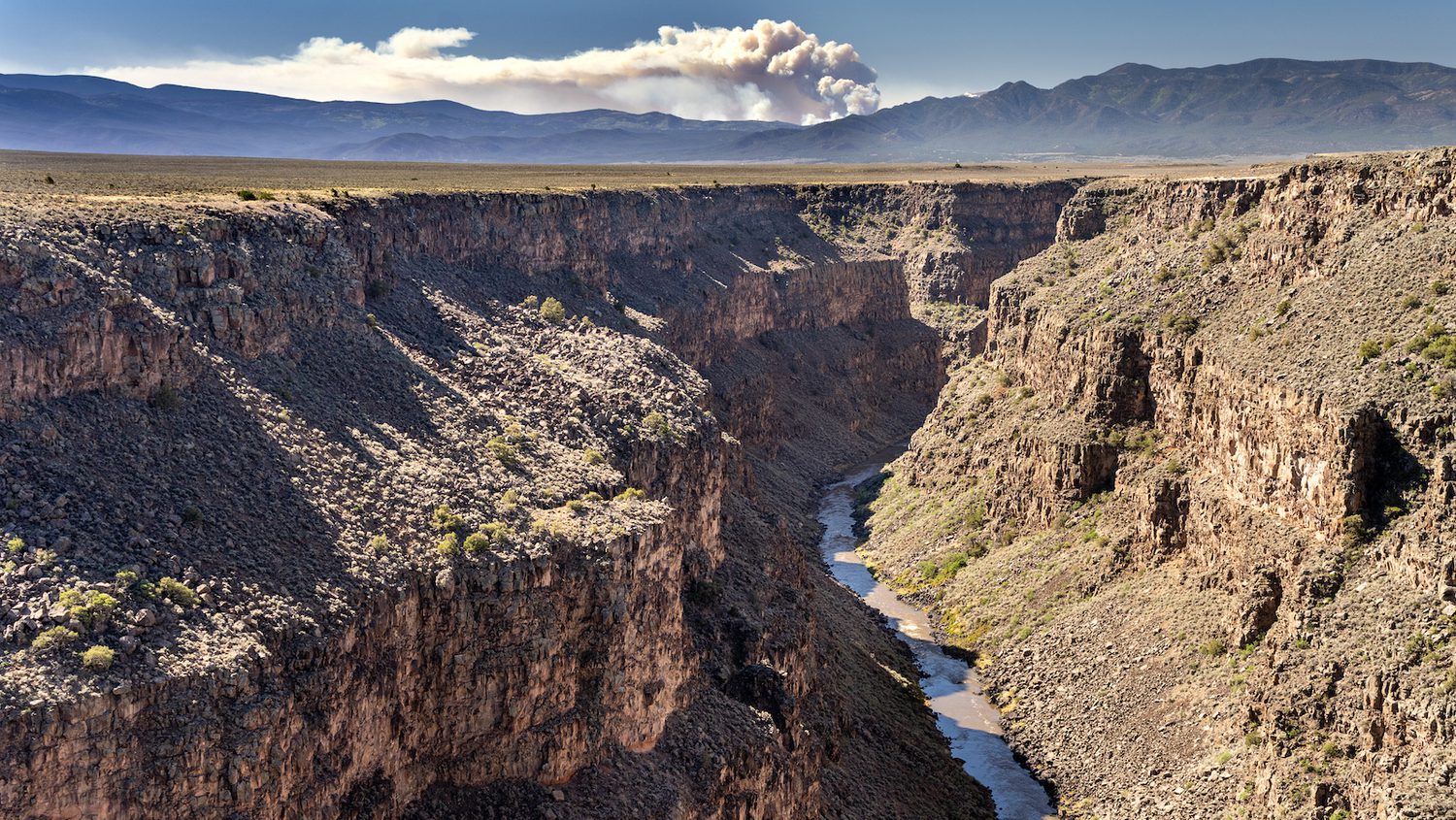
After the Rio Grande leaves Colorado, it flows into northern New Mexico and becomes a classic mountain river, rushing through thick forests and 1,000-foot-deep canyons. Then, when the Rio Grande emerges from White Rock Canyon, its character changes dramatically as it flattens out.

The Rio Grande runs through the Bosque del Apache National Wildlife Refuge, which is known for its sandhill crane migration.
In 1941, heavy mountain snows created a major flood that roared down the canyon and continued the length of the middle Rio Grande. It flooded roads, farms, towns, and downtown Albuquerque.
The mountain rivers of the U.S. West share this same fundamental characteristic. They drop rapidly in elevation, furiously carrying snowmelt and rain, and for millennia they have flooded annually, once or more. Each time they do, they spread out across the landscape and tear out the components of the existing ecosystem in and along the river, moving gravel, silt, rocks and logs and using that material to build a new river and riparian ecosystem.
This “disturbance regime” is akin to the effects of a forest fire that, in human terms, may be a catastrophe, but in ecological terms is how ecosystems rejuvenate and maintain their health.
Plant and animal species that live in and along the river have adapted to the ecological conditions of this flood pulse and thrive because of it. Cottonwood trees send out clouds of white puffs that are seeds, which fall on to the flood-moistened soil, allowing them to germinate and send down their first roots.
The endangered silvery minnow is designed to occupy the warm water in low-flow channels and to reproduce when there is a pulse of water in the spring. The river also provides critical habitat for more than 400 bird species and is vital as a resting and feeding station for migratory birds, including the spectacular sandhill crane migration.

The Cochiti Dam in Sandoval County, New Mexico.
The monster flood of 1941 carried a massive amount of sediment, spreading along some 200 miles of river and creating a foundation for the bosque of the middle Rio Grande, the portion in New Mexico. It is the largest cottonwood bosque forest in the U.S.
Humans have reacted to the flood pulse by blocking most of it. In the 1960s, officials began a project to prevent further damaging floods along the Rio Grande. They built the massive Cochiti Dam as a form of flood and sediment control. It is one of the largest earth-filled dams in the world, three quarters of a mile across, a black wall towering above everything else. It has achieved its engineering aim, stopping floodwaters and sediment from flowing downstream. But it has also destroyed the flood pulse ecology of the river and is causing the slow death of the bosque.
Without the recurring flood pulse, the Rio Grande bosque in New Mexico has dried out. While the 80-year-old riparian forest is beautiful in the brilliant May sun, it is geriatric — cottonwoods live at most about a century — and its days are numbered. There is no sprouting of new cottonwood forests, and willows are largely gone.
“This zombie cottonwood forest is facing an increasing array of stressors,” said Craig Allen, the USGS ecologist. “It’s the living dead. They are not going to be able to regenerate unless something changes. The whole riparian system has been transformed into something much drier.”
Meanwhile invasive Russian olive and tamarisk trees have moved in beneath the canopy, all fire-prone species. Fires in the bosque were once virtually non-existent; now they routinely break out. In 2017, the Tiffany fire in southern New Mexico roared across the parched landscape, leaving more than 9,000 acres of riparian cottonwood forest a charred ruin.

Bosque forests are dying out because the Rio Grande no longer floods.
Because of levees built to contain its flow, the Rio Grande now courses mostly through a narrow channel, rather than expanding broadly across the landscape, which disconnects the main stem from its many side channels. That has eliminated much of the meandering sloughs, braids, and oxbows, which are habitat for the silvery minnow, once present throughout the entire river but now found only in 10 percent of its range.
For some the answer to the existing problems with the Rio Grande is to restore some semblance of natural water flow.
“Optimizing the spring runoff is a really important strategy, because ecologically a whole bunch is tied to that,” said Paul Tashjian, director of freshwater conservation for Audubon Southwest. “The silvery minnow spawns during the pulse. Cottonwood seeds are flying during the pulse. Neotropical migrants are nesting during the pulse. If it happens a month earlier, it’s a misfire. It doesn’t provide those benefits.”
One strategy is to store water in reservoirs and allow it to be released at the right ecological time — easier said than done with so little water to go around and most of it committed to farms and ranches.
Thomas Archdeacon is a U.S. Fish and Wildlife Service fish biologist in Albuquerque charged with helping preserve the dwindling silvery minnow during a megadrought. He and his colleagues placed window screens to capture silvery minnow eggs as they flowed downstream. They planned to take the eggs to a federal fish hatchery, where the fish are bred. But there were no eggs on the morning we visited.

U.S. Fish and Wildlife Service biologist Mallory Boro examines a trap, hoping to harvest endangered silvery minnow eggs for a federal hatchery.
Another fundamental problem is that low flows and irrigation cause the river to dry up in the summer, resulting in large-scale die-offs. “If thirty miles of river dries,” Archdeacon said, “it will kill all the fish.”
Come July, Archdeacon and others will rush out to the dwindling river and catch fish stranded in pools and take them below a nearby dam, where they can survive in deeper, cooler water for a while longer.
The increasing frequency and size of forest fires is also taking a toll on the Rio Grande. As we drove along the river near Santa Fe in early May, we could see giant clouds of smoke pouring out of the raging forest fires.
“After the Las Conchas fire [near Los Alamos in 2011] there were huge impacts on the Rio Grande,” said Allen. “It was an extreme fire, and it caused extreme flooding and debris flow. It added an incredible amount of sediment and turbidity, and it changed the chemistry and biota. The macroinvertebrates and fish were wiped out.”
An effort is ongoing in New Mexico to thin large tracts of forest to reduce the risk of major wildfires and prevent further fire damage to rivers.
Martin Baca has seen the changes firsthand. He was born and grew up on a family ranch along the river near Bosque, New Mexico where he raises hay and bucking bulls for rodeos. He shows off a belt buckle the size of a bagel that he was awarded for high quality bucking bulls. Normal, he said, seems to be over. “There has been less water for irrigating and a lot more wind,” he said. “You can irrigate, and five days later it’s dry. That hot wind is a like a hair dryer. And there’s no dew. You need to have dew. It helps the grass grow. But you can’t get dew with that wind.”
“The climate is changing,” he said, pushing up the brim of his cowboy hat. “I didn’t believe it in the beginning, but I do now.”
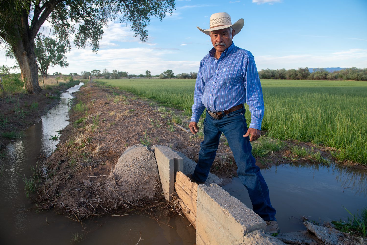
Rancher Martin Baca irrigates his hay fields with water from the Rio Grande.
Reporting for this article was supported by a grant from The Water Desk, an initiative based at the University of Colorado Boulder’s Center for Environmental Journalism.


