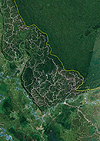
While officials in the state of Sarawak in Malaysian Borneo have insisted that 70 percent of the region’s forest cover is intact, satellite images indicate that far more widespread deforestation is taking place. A review of Google Earth images collected from GeoEye, TerraMetrics, and other satellite programs by the tropical forest Web site, Mongabay, reveals a network of logging roads and cleared forest across Sarawak. In contrast, the satellites reveal largely intact forests covering nearby Kalimantan — the Indonesian portion of Borneo — and the nation of Brunei. Advocacy groups have claimed that as much as 90 percent of Sarawak’s primary forest have been logged. Sarawak’s Chief Minister, Pehin Sri Abdul Taib Mahmud, under pressure from environmental groups that claim his family has acquired millions of dollars worth of holdings for his role in Sarawak’s forestry sector, last week invited independent inspectors to visit the state to verify the extent of forest cover.
Malaysian Forestry Claims Refuted by Google Earth Satellite Images
More From E360
-
MINING
In Coal Country, Black Lung Surges as Federal Protections Stall
-
Biodiversity
Older and Wiser: How Elder Animals Help Species to Survive
-
Climate
Rusting Rivers: Alarm Grows Over Uptick in Acidic Arctic Waters
-
ANALYSIS
A More Troubling Picture of Sea Level Rise Is Coming into View
-
INTERVIEW
Why Protecting Flowering Plants Is Crucial to Our Future
-
OPINION
Trying Times: Keeping the Faith as Environmental Gains Are Lost
-
ANALYSIS
As It Boosts Renewables, China Still Can’t Break Its Coal Addiction
-
OPINION
Can America’s Wolves Survive an Onslaught of Political Attacks?
-
MINING
As Zambia Pushes New Mining, a Legacy of Pollution Looms
-
Biodiversity
Long Overlooked as Crucial to Life, Fungi Start to Get Their Due
-
ANALYSIS
Species Slowdown: Is Nature’s Ability to Self-Repair Stalling?
-
OPINION
Beyond ‘Endangerment’: Finding a Way Forward for U.S. on Climate